
Five days in Da Nang, Vietnam, and the time just melted away. We landed in the city center first, did a Han River cruise that evening, and walked through the Han Market the next morning, not to buy anything, just to watch the rhythm of an old market that still runs on local commerce instead of being entirely staged for visitors. Then the cable car up to Ba Na Hills, a French colonial hill station at 1,487 meters that Sun Group rebuilt into cobblestone streets, a Gothic cathedral, and a bridge held up by giant stone hands rising out of the mist. Two nights up there, and the second day moved more slowly on purpose.
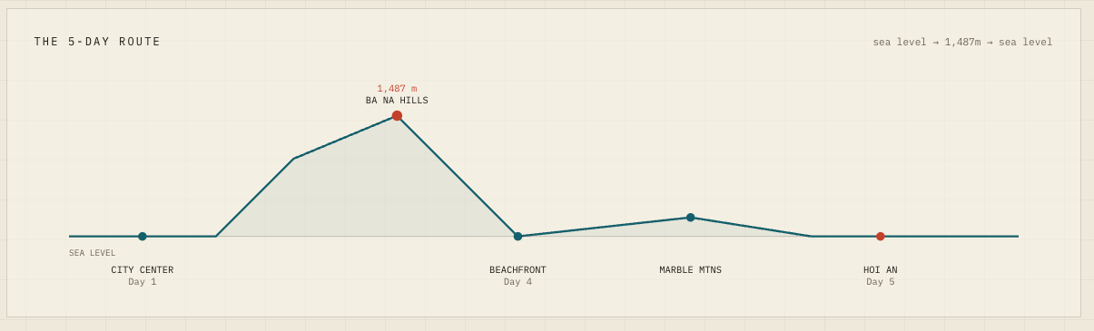
Back down to the beachfront, same city, a completely different rhythm—a slow swim off My Khe Beach, an afternoon with nothing planned. Half a day at the Marble Mountains, where ninth-century Cham stone carvings share a cave with a World War II field hospital. Then thirty minutes south to Hoi An for a lantern boat on the Hoai River and a coconut basket boat through the palm waterways of Cam Thanh, lantern-lit streets until past midnight. Sea level to 1,487 meters and back, and none of it gave us any trouble.
A different cafe every morning, coconut coffee, egg coffee, salted coffee, the traditional black, gave us an hour each day to just sit and talk, catching up with each other before the day's itinerary pulled us back in.
At some point, one of us said it. Why can’t we be like this in the Philippines?
What a circuit actually is
Most tourism strategies are built around destinations. The destination has to be compelling enough on its own to justify the trip. Boracay, Coron, and El Nido. Each clear that bar on their own terms. But worth flying across the Pacific for, on their own? That’s a different question; a case the Philippines has been making for decades without fully winning it.
In network terms, that’s the gap between a set of vertices and an actual graph. A collection of strong nodes connected by unreliable edges is just a list of places separated by friction.
Da Nang’s numbers exist because someone designed the system to produce them. 17.3 million overnight visitors in 2025, 7.6 million of them international, up 25% year on year, around $2.4 billion in tourism revenue. Da Nang’s airport handled 48,000 flights across 18 international routes. Tourism and services account for close to 70% of the regional economy. GRDP grew about 10% for the year, and the city is already building toward 19.1 to 19.5 million visitors for 2026, shifting its policy focus toward MICE, golf, luxury coastal property, and international weddings, the visitors who stay longer and spend more per day.
What we felt on the ground was simpler than any of those numbers. The rides were bookable in minutes. Prices were what they said they were. Nobody got lost or overcharged, and the transitions between places were low-effort enough that we stopped thinking about them, which left more attention for the places themselves.
The Philippines isn’t short on destinations. Corregidor is Pacific War history on a fortified island. Intramuros is four centuries of colonial Manila in a few walkable kilometers. El Nido and Siargao need no introduction. What breaks down is everything between them.
The drive from the airport to Makati takes under 20 minutes. The going Grab rate runs around ₱300. I once paid ₱1,500 for a private hire (because I couldn’t book a ride) on the exact same route, five times the fare. A first-time visitor has no way of knowing the ₱300 fare even exists. They pay the ₱1,500, file Manila under expensive, and tell their friends when they get home. None of that is invisible, and it sticks to a destination’s reputation long after the trip is over.
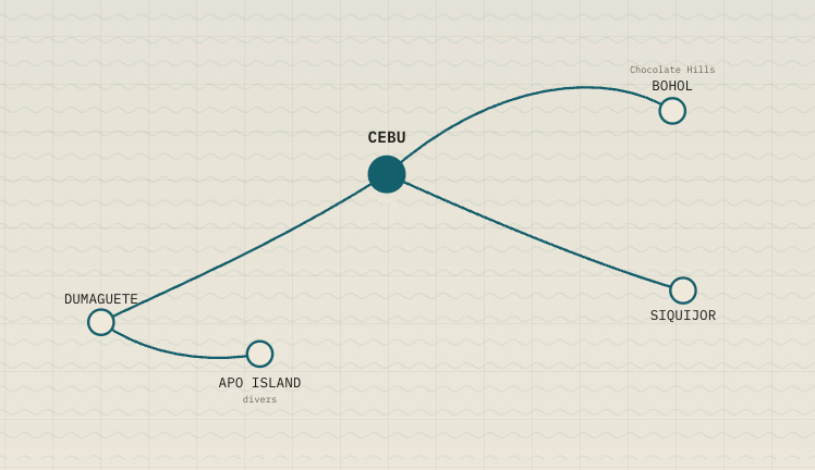
The Visayas already has the shape of a real circuit, if anyone built it on purpose: Cebu as the hub, Bohol for the Chocolate Hills, Siquijor for the parts of its reputation worth explaining in person, Dumaguete and Apo Island for the divers. Link them deliberately, and a choose-one trip becomes a stay-for-two-weeks itinerary, maybe even three weeks.
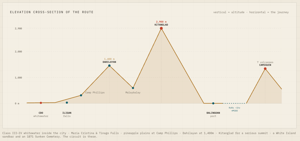
I ran a version of the same thought experiment on my own region. Ten days from a single runway in Cagayan de Oro: west to Iligan for Maria Cristina and Tinago Falls, south up the Sayre Highway into the Bukidnon highlands, then east to the coast for an hour-long RoRo crossing to the volcanic island of Camiguin. Sea level to 2,900 meters within a hundred-odd kilometers of one airport. Class III to IV whitewater inside Cagayan de Oro itself, the pineapple plains at Camp Phillips, Dahilayan at 1,400 meters, a serious summit at Mount Kitanglad, and on Camiguin, the White Island sandbar and the Sunken Cemetery from the 1871 eruption. The circuit is already there. Nobody has built it.
Reliability is the infrastructure
In transport modeling, travel-time reliability gets weighted more heavily than travel time itself. For someone local, a schedule that drifts by half an hour is a shrug. For someone sequencing ten days from Seoul, that drift is the trip. Travelers plan around the worst plausible crossing instead of the average one. The Balingoan-to-Camiguin ferry averages about 60 minutes, but a visitor has to plan for the 95-minute version, because that’s the number that determines whether the rest of the day’s itinerary still works.
A ferry timetable that holds steady month after month is infrastructure, even though no concrete is poured for it. So is a road leg whose travel time you can actually count on.
Reliable transport is the easier half. The more challenging problem is that edges don’t have obvious owners. My ten-day circuit crosses four provincial boundaries: Lanao del Norte, Bukidnon, Camiguin, and Misamis Oriental, where Cagayan de Oro sits as a highly urbanized city governed independently of the province around it. Each local government counts the number of arrivals at its own attractions. Almost none of them can say where those visitors slept the night before, or where they went next.
That’s edge data, origin-destination flows, and without it, every infrastructure argument stays anecdotal. DOT Region X is the only actor whose mandate already spans all five jurisdictions.
A scrollytelling version of this essay, with the maps and the data visualized, is up at erikalegara.com/the-edges-matter-too.